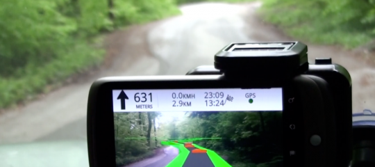
 Wikitude Drive is a satnav system that uses augmented reality to overlay a route on to a live video stream.
The company behind it has launched a beta version for testing that works worldwide. The software is compatible with Android based smartphones and allows the system to either use a live video stream, or 3D maps if you prefer.
Driving directions not only appear on screen, they are overlaid on the live video stream of the very street you are driving on. As a result, you are seeing the real world and real road in front of you, while being directed by a digital route on top of it.
By using augmented reality it lets the driver see exactly where he needs to turn as the route will show exactly at which point to turn on the video link – ie, the real world.
Secondly, Wikitude Drive solves a key problem that all other navigation systems have. These systems require the driver to take his eyes off the road in order to look at the abstract navigation map. Just by looking at the map screen for one second when driving at 100 km/h (62 mph), the driver is actually ‘blind for 28 meters (92 ft). Think about how much can happen in those precious meters. Since Wikitude Drive provides you with driving directions on top of the live video stream, you still see what is happening in front of you when looking at the display of your mobile AR navigation system.
The mapping data used is from Navteq and in the future, it will be coupled with a database of millions of POI from around the world.
The video below shows the augmented reality satnav in use. Hopefully it’s as impressive as it looks.
Full details at Wikitude where you can find information (for those in America) on getting one of the 2000 beta downloads available.


Speak Your Mind
You must be logged in to post a comment.